Category:RAF Tangmere
Jump to navigation
Jump to search
| Object location | | View all coordinates using: OpenStreetMap |
|---|
airport in the United Kingdom  | |||||
| Upload media | |||||
| Instance of |
| ||||
|---|---|---|---|---|---|
| Location | Tangmere, Chichester, West Sussex, South East England, England | ||||
| Operator | |||||
| Inception |
| ||||
| Date of official opening |
| ||||
| Dissolved, abolished or demolished date |
| ||||
| IATA airport code |
| ||||
| ICAO airport code |
| ||||
 | |||||
Media in category "RAF Tangmere"
The following 18 files are in this category, out of 18 total.
-
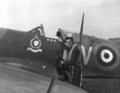
 A Hawker Typhoon Mk IB of No. 486 Squadron RAF, 27 October 1943. CH11578.jpg 2,459 × 1,772; 1.04 MB
-

-
 CH 004015.jpg 761 × 800; 57 KB
-
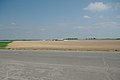
 Glasshouses at Tangmere Airfield - geograph.org.uk - 1534067.jpg 640 × 427; 98 KB
-
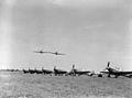 Hurricanes 006771.jpg 800 × 592; 123 KB
-

-
 RAF Tangmere - 10 Feb 1944 Airphoto.jpg 826 × 695; 188 KB
-
 RAF Tangmere - geograph.org.uk - 2383809.jpg 640 × 428; 33 KB
-
 RAF Tangmere Control Tower - geograph.org.uk - 1177618.jpg 640 × 480; 69 KB
-
 Royal Air Force 1939-1945- Fighter Command CH12060.jpg 800 × 507; 55 KB
-
 Royal Air Force 1939-1945- Fighter Command CH4014.jpg 763 × 800; 56 KB
-
 Royal Air Force 1939-1945- Fighter Command CH4624.jpg 763 × 800; 51 KB
-
 Royal Air Force Fighter Command, 1939-1945. CH6771.jpg 800 × 592; 39 KB
-
 Spitfire at RAF Tangmere.jpg 765 × 469; 96 KB
-
 Tangmere Airfield - geograph.org.uk - 236235.jpg 640 × 479; 105 KB
-
 Tangmere Airfield - geograph.org.uk - 236240.jpg 640 × 479; 95 KB
-
 Spit.gif 796 × 619; 384 KB
-


